Ever since "the Mavromati incident" on our first trip, I have taken to cross-referencing each site both with my Mythological Atlas of Greece, Google maps and/or Waze, and most importantly, Google satellite view. The first indicates that there is something, and gives a pretty good location relative to roads and other monuments which existed at the time of publication around 2002. The second confirmation location relative to now existing roads and monuments for navigation. And the last I used to just use as a further confirmation of location, especially when the site is not immediately adjacent to a road, but now I also use it to determine the extent of the site.
On Google maps, an archaeological site of any era (e.g., Greek, Roman, Byzantine) has a special symbol like a rook chess piece. If one were to search for Eritrea, Greece, at 200m - 1", you might see something like this:

 Now the theatre also has a temple, and we can see that the West Gate is in the archaeological site, which is much more than a mere gate. And there are Roman baths, although I am not interested on those.
 That second mystery marker is a House of Mosaic. But there is also now a Craftwork Quarter and a new mystery marker next to the Altar of Herakles.
 South of the temple of Apollo Daphenophoros, there is now an Ancient Agora and a Tholos, at the very least...
 And there is also a significant Acropolis.
 Obviously, a theatre. And obviously, it is closed because it is undergoing some restoration. No problem. I only had to climb on the concrete wall and lean over the fence to get these shots. I'll also note that I could have very easily scaled the fence and gone into the site, but at least in Euboea there is a notice posted in both Greek and English warning about "any damage to the enclosure" is subject to a fine and a minimum of two years imprisonment for violations. Legally speaking, there is obviously a difference between "damage to property (the enclosure)" and "trespassing", but I'm not able to argue that in Greek, yet.
 However, there was also a temple--the temple to Diolysos and the altar within the theatre site. Ok, a little harder to get decent pictures, but there also isn't much to the temple other than the bare foundation. I might have enjoyed analyzing the cavity beneath the floor, but as the site in this area had not been maintained, I'd only be looking at weeds growing out of the center, and I could see that plainly from this perspective. Pushing on.

 View of Room n (peristyle) from NE corner. You can also see the plumbing lines in the ground.
 Room l (courtyard) looking into Rooms a, a-1 and a-2. Of course if we didn't already know that "a" was the kitchen and "a-2" was identified as a bathroom, we joked that this could be an office...or a nursery... Cue the laugh track.
 Room d (living room) into Rooms e and f (banquet rooms).
  Ruins among the weeds.
 Crazy overlapping layers of construction.
 West Gate
 Temple of Apollo Daphnephoros, which was so heavily influenced by concrete, it was hard to tell what was reconstruction of an original and what was just added for some unknown reason.
 The Hellenistic Baths. If you've been paying attention, you will note that this was never shown on the map, even at 20m resolution, but it is located at the very southern part of the map which has the temple to Apollo. You can even see the ruins in the picture in a weirdly polygonal shaped area bounded by a curved road. This site was also locked, but you could walk around it completely.
 Tholos. I did my level best to take a decent picture, but as you can see, there is a house impinging on the tholos, and it looks like something out of a horror movie. Also, the whole site is fenced and locked, or I would have tried from the other direction.
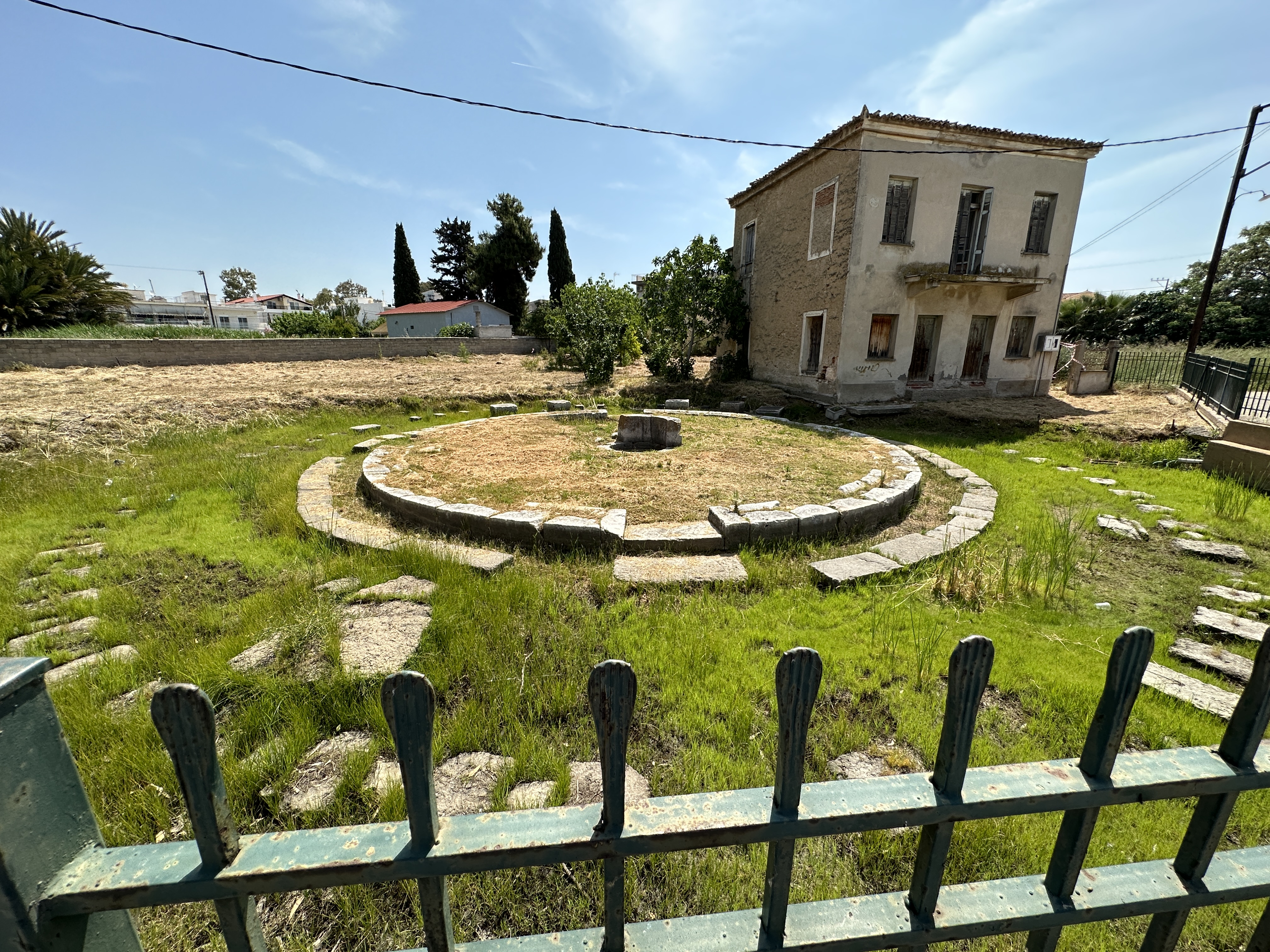
 Modern day agora is a park with a wide pedestrian walkway bisecting in two directions making it into quadrants.
  Naos tis Isidos or Greek temple of Isis. There are surprisingly a few temples to Egyptian deities, one in Glypha that we ignored because it was in the middle of a field and it was pouring, and one in Marathon. Also, this was yet another site that I found when was navigating us around the city, along with a Palaestra, across the street which was behind a locked gate as well as an overgrown field. We didn't even both to try to get pictures there. By this time, we were annoyed that nothing was open and/or maintained to any reasonable level. If you are going to gate it off, then maintain it. Otherwise, the flora will take over and eventually take it back. Stepping off my soapbox.
 This was listed as the "Craftwork Quarter" on the map, and I fully expected to see small workrooms where pottery or textiles were produced. Instead, we were confronted with a yet another locked site, a slab of concrete and couple of undecipherable random walls.
 Then the Gimnasio, which was kind of interesting, except it was locked. There were a few signs inside the site which we could see from outside the fence. And one particularly amusing sign on one side of the fence which indicated note to take photographs. Too late, not that with all the weeds, any photograph would spoil the surprise.
 Altar of Herakles. Now, seriously, this was about the worst site I've seen. It's listed on Google maps as the Altar of Herakles", but the signs at the site say "The North Quarter of the City: The Panathenaic Amphorae Quarter". There noted to be, among the houses, a "roadside shrine to Hercules[sic.]" which was the circle structure in the photo. Given the proportion of altar/shrine to other structures which are houses, truly, was the most important thing here the altar? I will also note that the other "North Quarter" is about 50m NE of here, so where does the "north quarter" really lie?
 Roman baths. Check.
 The Sebasteion (Temple of Augustus). Oh sure, there is a small temple building on the foundation from the Hellennistic period, but this is about a road wide enough for two Roman chariots. Can't you just see the drag racing?
 Gorgon head mosaic.
 Fresco of heroes battling demons, and foreground of griffons and other mythical beasts. The truly amazing thing about the artistry of these mosaics is that even with the repeated and book-matched animals, there are subtle variations in the face (eyes, ears, hair) which make they unique. It was reminiscent of the Caryatids, which were individually designed to be unique, especially with their braids.
 We had missed the fountain (which was noted to be temporarily closed) and the eastern gymnasium. We still had the two Sanctuaries and the Acropolis to do, so we headed back to the foothills and drove the car as far at the road existed. Unfortunately, the weeds really were going to be the last straw for us.
No comments:
Post a Comment