 Impending
 Imminent
 Emerging
 Clear Impending Imminent Emerging Clear
I didn't have a schedule or itinerary for our stay in the Peleponnese, which turned out to be fortuitous since a recently published article about the overlap of Minoan and Mycenaen culture gave us a new goal. Having been to Crete and visited half a dozen Minoan site, including three palaces, it only seemed appropriate to revisit the Mycenaen counterparts again. We are going to leave the analysis and synthesis of what we observed between the two cultures for a separate post, but for now, here are new pictures of the fortified acropolis and palace at Mykines.
 The famous Lion's Gate. As this site was open later for "summer hours" and on a Tuesday (!), later in the afternoon all the tours had departed, and it is possible to get clean photos.
 Or one just with Randall!
 The Great Ramp--not ADA compliant.
 The Cult Center


 Building Delta.
 House of Columns

That classic Mykenean entrance, left from the northeast gate, and right from the bottom of the cistern staircase.

 More STAIRS!!
 View from the acropolis into the valley below, with elevation of House of the Merchant Group, Grave Circle B, and Tholos tombs. We elected not to wander there again as by this time we had come to the conclusion that low foundation walls without a good site map wasn't as useful.
But here is a site map of the area, for reference.

We were surprised to see a tour bus, and pleasantly surprised to learn that entrance was free (had been 6€), but it also appeared the site was unattended, which is unusual for the larger sites, and especially one that used to charge a hefty admission (others are generally 3-4€, unless it is a UNESCO World Heritage Site, which can run 12 or 20€). Unfortunately, the reason there was no fee and no attendant soon became clear. The site, other than the area immediately around the temple, had been left to the weeds.
So, while I was able to take much better pictures of the temple because the sun cooperated, everything else is swathed in weeds. Low level stuff--4-6"--grows over the areas where there are stones close to the surface. Other areas are subsumed in knee deep grasses and scrub, and sometimes waist deep. I had to give up, which made me sad because this had been a place that was amazing and told so many stories. From the upper level with its original stone floor and some partial remaining foundation walls of the older temple, to the connected double stoa colonnades and the second lower stoa and colonnade, to the impressive baths which channeled water to two successive lower levels. These were now barely discernible.


 Upper level stoa and colonnade (left), three steps to stoa (buried under weeds). Note, this stoa is connected to the other side of the steps leading to the alter, but which is also obscured in brush.
 Stairs to altar.
 Altar, which is both supporting an improvised "herb" garden and also inaccessible due to knee high grass and scrub.


 Architectural element with double key design (left); Triglyph segment (right).
As an aside, this site starts at 400' elevation, and has a steep hike to 600' to the ancient temple, which is necessary in order to understand the site because...there is no site map. For point of reference, the road turnoff which leads to the site is at 110', and if you know where to look, this is visible from the main road driving into Nafplio.
This is the inverse of Animals in Unusual Places.
On our first trip to Greece, we made a list of things that you could be guaranteed to hear/see every day, no matter where you were. Roosters crowing, not just at daybreak, a herd of something (goats, sheep), snails (or at least the evidence of them).
We also made a list of unusual (rare) animals that we did see. So far, we are making good progress on seeing all of those animals again (perhaps they are not quite so rare, but then we are unusual tourists venturing into some unconventional areas).
While trekking to/from the fortress at Eleutherai we saw two snakes, which we think were grass snakes. I saw mine first, and my shriek filled the valley. Randall remained calm and silent when he saw his, but his was only 18", whereas mine was a good 36"! We also saw two wild boar, which were just as confused by us as we were of them, and went running off into the brush.
There are also an abundance of owls. Doesn't matter if you are in rural Greece or downtown Athens. You can always hear owls hooting. While at Mycenae, we heard three of them hooting at the same time, all in 5/4 (hoot hoot rest hoot rest, repeat). Once Randall got the pattern in his head, he couldn't unhear it. You're welcome!
 View of the port from the fortress.
 Outside the fortress.
 Entrance through the North Wall.
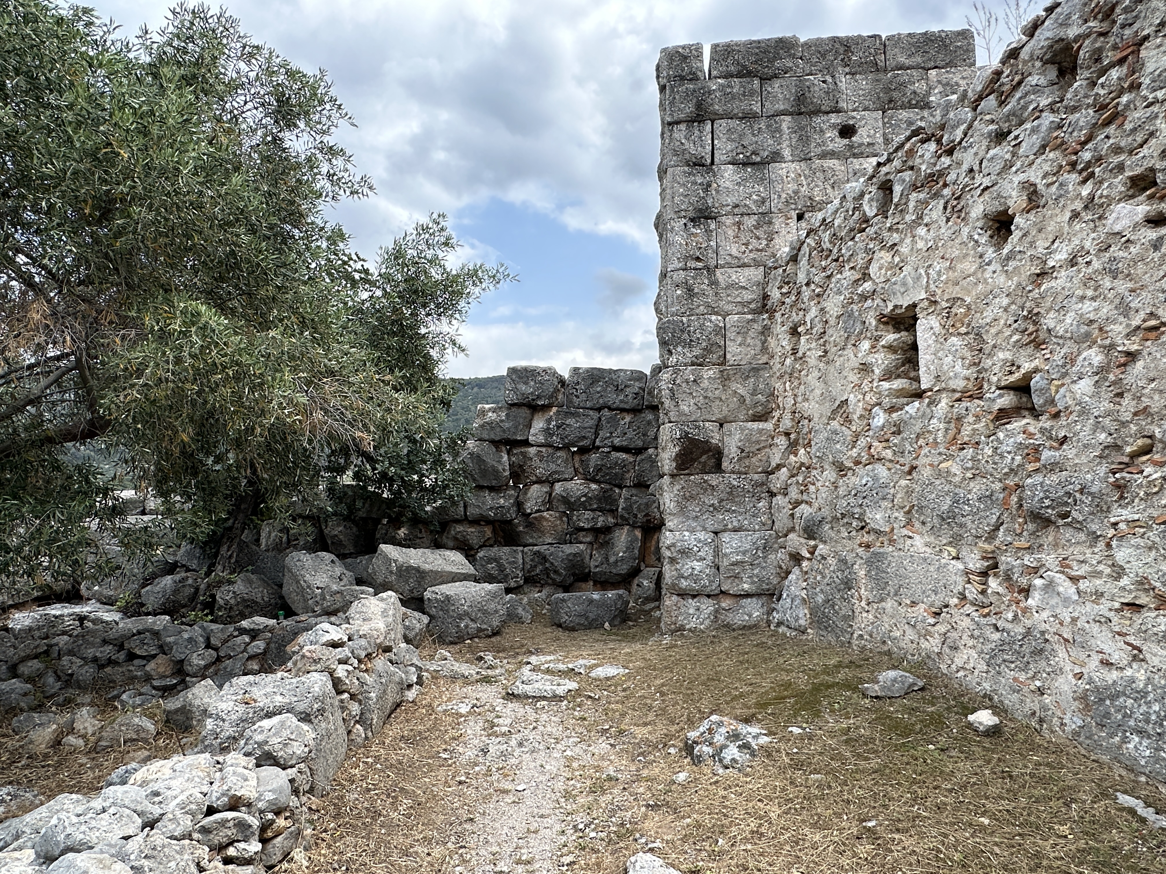 Inside the fortress
 Rebuilt Tower
 Discussion of the history of deterioration of the tower, including archival photographs from which the design of the restoration had been based.
 Top floor (of 3) of the tower, showing wood beam reconstruction, windows for defense, and wood flooring. The attendant at the site explained that the each of the three 9m cross beams were hewn from chestnut trees.
 Second floor, showing slit windows and ceiling construction.
  New stone from the original quarries was used. After 2500 years, it will age to the same color as the adjacent stones.
 View of the fortress from the tower.
 Rebuilding the Northeast Tower!
  Gratuitous photo of the tower from outside the fortress.

On Monday the 22nd we needed to transition from Chalkida in East-Central Greece to Napflio on the Peloponnesus. This gave us a number of options for what to see as presented by our trusty "Mythological Atlas of Greece." No matter what, we'd be passing through what was in ancient times Boeotia, aka 'Central Greece, north of Athens.' Thebes (more correctly, Θήβα, or in Roman characters 'Thiva') is in this region; once again, we skipped it. The relevance of this, however, is that back in the day (aka, the late 5th and 4th centuries BC) this area was a hotbed of military activity because the main road between Athens and Thebes runs right through the area we'd be crossing. Unsurprisingly, the atlas noted there were a number of 'fortresses' in the area - if you've got warring cities, you're going to get fortresses.
So, we decided to hit two of them. One (Aigosthena) had opening hours (8:30-3:30) and Google maps showed there was a lot of stuff going on nearby, including a nice road up to the site. The other was the fortress at Eleutherai. It was clearly huge, albeit only partially surviving, and the official Greek Culture site noted it was 'always accessible to the public' and there was 'no entrance fee'. Translation: "It's a bunch of rocks in an open field. Good luck!"
Still, it looked interesting, so we decided to give it a try. Here's the Google Map of the site:

Note that Google marks a 'road' going from where we parked the car to where the main entrance to the fortress is marked. Here's what the starting point for our walk looked like.

I have no idea what the minimum standards are for 'road' in Greece, but they don't include the ability to take vehicular traffic. This next picture, for example, was taken about 100m further up the 'road' which was now about 5ft wide, covered with small stones, and with a 10 degree slope leading directly into a 100m gorge.

Lauren will post about some of the animals we saw on the way, but I'll note that at no point in the journey could a car of any type survived. The road also goes up about 75m over about 750m. Indeed, when coming down I lost my footing at least once, and Lauren never would've made it except for the crucial assistance of 'stick', forever memorialized here:

Nonetheless, we made it up to the fortress to find that, indeed, it's in fantastic shape.


Some more photos to show how well this site is preserved, and how impressive it must have been when first built:


What really made the site interesting was the post-visit analysis. I was curious as to why someone would build a fortress here, and who built it. The on-site plaque noted that it was built in 370-360BC and was part of the Athenian defense system built at the time. The official Greek culture site gives a few more details:
Now, the idea that the Eleutherians gave up Thebes in favor of Athens seems to be on-spec. However, recent research suggested that the fortress was actually built by the Thebans (or Boeotians more generally), again in the early parts of the 4th century BC. Following this up, there was a huge amount of work done on this fortress published by Fachard et al (2020) that makes for fascinating reasoning. They did a detailed search of the entire fortress area (a person every 10m!) and found, amongst other things, a Boeotian seal that would've been used by a civil servant to mark weights & measures back in the 4th century BC and argue that this strongly suggests the place was built by them, and not by the Athenians. They also point out some fascinating bits of information about how the masonry was done, and even note that the fortress was used by Greek guerrilla fighters during WWII. All-in-all, a fascinating place. But not the easiest to get to...The archaeological site of Eleutherai, on the old Athens-Thebes National Road, north of the Villia junction, encompasses part of the lowland and rocky hill, where the ancient fortress, known as Gyftokastro, stands. Eleutherai was allegedly the birthplace of Dionysus, who founded the homonymous city and was thus called Dionysus Eleuthereus. Originally a Boeotian city, Eleutherai went over to Athens in the sixth century BC. The cult statue of Dionysus Eleuthereus was reportedly moved from Eleutherai to Athens on Peisistratus' orders, leading to the establishment of the homonymous sanctuary on the south slope of the Acropolis. Strategically located on the borderline of the Athenian territory, with control over the narrow passage between Athens and Thebes and overlooking the plain of Oinoe, Eleutherai was part of the Athenian defence network in the fourth century BC. The archaeological site has been cleared of undergrowth.